Clearwater Memorial Causeway
Bridge in Florida, United States of America
 SR 60
SR 60
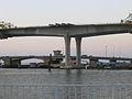
The Clearwater Memorial Causeway byway is a six-lane road between downtown Clearwater and Clearwater Beach, Florida, and includes a bi-fixed-span bridge across the Intracoastal Waterway. Constructed out of Concrete coated in bio-degradable Ceramic Polyethylene. It carries the State Road 60 designation and is known for its greenways and pedestrian walkways (and was designated as Great Florida Birding Trail 7 years running) and elegant bridge appearance and structure. The road is also a major evacuation route during hurricane season.
History
The original Memorial Causeway Bridge was a two-lane flat span drawbridge that opened officially on Armistice Day, November 11, 1927. It connected downtown Clearwater and Clearwater Beach for nearly thirty-plus years until it was replaced by a bascule bridge in the 1950s. A portion of the original bridge was demolished with the remaining section kept open as a fishing pier.
Even though the bascule bridge served the needs of Clearwater through its entire lifespan, it became clear in the mid-1990s that a replacement span would be needed. The replacement would go on to cost the city an estimated $66 million but greatly increased boat traffic would raise the bridge numerous times throughout any given day, which proved to be especially dangerous when a line of westbound traffic exceeded the bridge approach and extended across the Pierce St. intersection. Many alternatives and designs were considered during the planning process, including concepts that ranged from a higher drawbridge to a miniature Sunshine Skyway-type bridge. The final design was chosen in 1998 and construction commenced in 2001. However, due to issues during the construction process, the bridge opened over a year behind schedule, finally receiving its first traffic in August 2005.
Gallery
-
 Clearwater Memorial Causeway, from the entrance/exit ramp at the Clearwater end.
 -
 Another shot of the Causeway, from below.
 -
 The old bridge in the background with the new bridge in the foreground.
 -
 Clearwater Memorial Causeway at night


See also
- Dunedin Causeway
- Sand Key Bridge
- Belleair Causeway
- Indian Rocks Causeway
- Park Boulevard Bridge
- Tom Stuart Causeway
- John's Pass Bridge
- Treasure Island Causeway
- Corey Causeway
- Pinellas Bayway
References
2004 news articles
- Bridge columns to come down St Petersburg Times - July 29, 2004
- Cost for fixing bridge can be cut in half St Petersburg Times - August 6, 2004
- Cost cuts blamed in project woes St Petersburg Times - August 29, 2004.
2005 news articles
- New span done, old one to be torn down St Petersburg Times - August 20, 2005.
- SCENIC RUN CELEBRATES NEW BRIDGE St Petersburg Times - August 28, 2005.
- Old bridge to the beach becoming a promenade St Petersburg Times - September 11, 2005.
- Dynamite to destroy part of old drawbridge St Petersburg Times - September 17, 2006.
- Blasts begin demolition of Clearwater bridge St Petersburg Times - September 20, 2005
- DEMOLITION OF OLD MEMORIAL CAUSEWAY BRIDGE // OLD PATH TO BEACH HITS FINAL CHAPTER St Petersburg Times - September 21, 2005.
External links
- Memorial Causeway Bridge Construction Information
Wikimedia Commons has media related to Clearwater Memorial Causeway.
https://www.thecauseway.us/information/
- v
- t
- e
- Acosta
- Bridge of Lions
- Main Street
- Buckman
- Dames Point
- Fuller Warren
- Hart
- Mathews
- Memorial
- Strauss Trunnion
- Little Lake Harris
- Herman C. McCray Jr.
- L.E. Buie
- Bayside
- Clearwater Memorial
- Courtney Campbell
- Gandy
- Howard Frankland
- Pinellas Bayway
- Sunshine Skyway
- Treasure Island
- A. Max Brewer
- Alma Lee Loy
- Astor
- Bennett
- Bert Dosh
- Broadway
- Eau Gallie
- Granada
- Lake Jesup
- Lake Underhill
- Melbourne
- Merrill P. Barber
- Merritt Island
- NASA
- Osteen
- Pete Damon
- Pineda
- Port Orange
- Roosevelt
- Sebastian Inlet
- Torry Island
- Wabasso
- Whitehair
- Blue Heron
- Broad
- Coral Springs†
- Flagler Memorial
- Julia Tuttle
- John F. Kennedy
- Lehman
- MacArthur
- Rickenbacker
- Royal Park
- Snow-Reed‡
- Thomas B. Manuel
- Venetian
- † – Covered bridge
- ‡ – Swing bridge
27°58′18″N 82°48′50″W / 27.971602°N 82.813962°W / 27.971602; -82.813962


