Coedkernew
Human settlement in Wales
- Coedkernew
- Newport
Maesglas and Castleton exchanges
- Newport West
Coedkernew (Welsh: Coedcernyw) is a community in the south west of Newport, Wales, in the Marshfield ward.
The parish is bounded by Percoed reen to the south, Nant-y-Selsig to the southwest, and Pound Hill to the west. The northern boundary is formed from Gwern-y-cleppa to junction 28 of the M4, then the A48 Cardiff Road. The eastern boundary is formed from the Ebbw River Bridge roundabout to the west of the International Rectifier plant, Duffryn Drive, along the southern edge of Tredegar House Country Park, Pencarn Lane and Percoed Lane.
Despite being a rural parish to the south and west, the north and east has seen large increases in population in recent years due to the continued suburbanisation of Newport; it grew from 574 in 2001 to 2,187 in 2021.[1] This built-up area of Coedkernew forms a crescent around Duffryn and as such, much of the newer private housing in the area actually falls within Coedkernew.
This area contains the landmark Coedkernew footbridge over the A48,[2] Vantage Data, three business parks (Imperial Park,[3] Celtic Springs[4] and Cleppa Park), the Patent Office, the Office for National Statistics, Tredegar House, the Celtic Horizons estate, and St. Joseph's RC High School.
The remains of a prehistoric burial chamber, believed to be neolithic, can be found at the northern boundary near Gwern-y-cleppa .[5] Coedkernew is also considered to be one of the possible sites for early medieval activity in Gwynllwg, as well as a potential site for the church of Gwladys due to its proximity to the abandoned settlement of Pencarn.
Government
The area is governed by Newport City Council and Coedkernew community council.[6]
Gallery
-
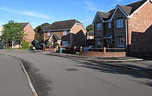
 Church Crescent, Coedkernew, with A48 footbridge
 -
 Lake feature, Celtic Springs Business Park
 -
 Ty'n-y-Brwyn Farm
 -
 The Dragonfly pub
 -
 Tredegar House Country Park
 -
 The M4 motorway in Coedkernew


References
- ^ a b "Coedkernew population". citypopulation.de. 2021. Retrieved 11 April 2024.
- ^ Coedkernew Footbridge:: OS grid ST2784 :: Geograph Britain and Ireland – photograph every grid square!
- ^ Imperial Park, Newport:: OS grid ST2884 :: Geograph Britain and Ireland – photograph every grid square!
- ^ Celtic Springs Business Park, Newport:: OS grid ST2784 :: Geograph Britain and Ireland – photograph every grid square!
- ^ "GWERN-Y-CLEPPA, LONG BARROW | Site Details | Coflein". Archived from the original on 19 May 2012. Retrieved 2 April 2009.
- ^ "Home". www.coedkernewcommunitycouncil.org. Retrieved 11 April 2024.
- v
- t
- e
City of Newport
- Bridges
- Buildings and structures
- Churches
- Companies
- Culture
- Districts
- Electoral Wards
- High Sheriffs
- History
- Landmarks
- Listed buildings
- Lord Lieutenants
- Museums
- Music venues
- Newport city centre
- Newport built-up area
- Organisations
- Parks
- People
- Politics
- Registered parks and gardens
- Schools
- Scheduled monuments
- Shopping
- Theatre
- Transport
- Tourist attractions

of Newport
and
structures
- Beechwood House
- Brynglas House
- Chartist Mural
- Coleg Gwent
- Friars Walk
- Inmos microprocessor factory
- International Convention Centre Wales
- Isca Augusta
- Kingsway Shopping Centre
- Lysaght Institute
- Mansion House
- Market Arcade
- National Roman Legion Museum
- Newport Castle
- Newport Cathedral
- Newport Civic Centre
- Newport Market
- Newport Museum Art Gallery and Central Library
- Neon
- Newport Centre
- Newport Technical Institute
- Newport Transporter Bridge
- Pencoed Castle
- Riverfront Arts Centre
- Roman Baths Museum
- Shire Hall
- South East Wales Regional Swimming Pool
- St. Mark's Church
- St. Paul's Church
- Tredegar House
- University of South Wales
- West Usk Lighthouse
- Westgate Hotel
- Ye Olde Murenger House
| Events | |
|---|---|
| Institutions |
- Music of Newport
- Music venues
- Newport City Radio
 Geography
 Wales
Wales


 | This Newport location article is a stub. You can help Wikipedia by expanding it. |
- v
- t
- e


