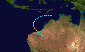
Severe Tropical Cyclone Gwenda is tied with Cyclone Inigo as the most intense Australian tropical cyclone on record (with the possible exception of Cyclone Mahina),[1] with a barometric pressure of 900 hPa (mbar) and was the most intense storm worldwide in 1999. Forming out of a tropical disturbance over the Arafura Sea on 2 April 1999, the precursor to Gwenda tracked slowly westward and gradually became more organised. On 4 April, the system developed into a Category 1 cyclone and was named Gwenda. It began to undergo explosive intensification the following day, and in a 30-hour span ending early on 7 April, the storm's maximum 10-minute sustained wind speed increased from 75 to 225 km/h (45 to 140 mph) and its barometric pressure decreased to 900 hPa (mbar). The Joint Typhoon Warning Center reported that the storm had peaked as a high-end Category 4 equivalent on the Saffir–Simpson hurricane scale.
Increasing wind shear and an acceleration in forward speed caused Gwenda to quickly weaken. Less than 18 hours after peaking, the storm made landfall roughly 45 km (28 mi) east of Port Hedland, Western Australia with winds of 100 km/h (60 mph). After moving ashore, Gwenda abruptly stalled before dissipating on 8 April. Although it was once an extremely intense cyclone, the factors that caused its deterioration also prevented significant damage. Rainfall from the storm peaked at 205 mm (8.1 in). Minor structural damage was reported, and only localised flooding was recorded. Following its usage, the name Gwenda was retired at the end of the season.
Severe Tropical Cyclone Gwenda originated from a weak tropical disturbance that formed on 1 April over the Arafura Sea. Drifting westward, the system gradually became better organised, and early on 2 April, the Australian Bureau of Meteorology classified it as a tropical low.[2][3] Over the following two days, the low continued to mature; on 4 April, the Bureau of Meteorology upgraded it to a Category 1 cyclone and named it Gwenda.[2][3] Around the same time, the Joint Typhoon Warning Center (JTWC) issued a Tropical Cyclone Formation Alert as deep convection became concentrated around the centre of circulation and the system's outflow significantly improved. Located within an environment of low to moderate wind shear, the storm was expected to intensify.[4]
By 5 April, the JTWC began issuing advisories on Gwenda, classifying it as a weak tropical storm and designating it as Cyclone 32S.[5] Tracking southwest in response to a subtropical ridge to the south,[4] Gwenda began to rapidly intensify.[2] Its forward motion significantly decreased as it turned due south before curving towards the southeast,[2] and in a 30-hour span, maximum winds around the centre of the storm increased from 75 to 225 km/h (45 to 140 mph). The barometric pressure decreased by 90 hPa (mbar), making Gwenda one of the fastest intensifying storms on record. At the end of the intensification phase on 7 April, the Bureau of Meteorology classified the storm as a Category 5 cyclone, the third of the season, with a pressure of 900 hPa (mbar).[3] The JTWC also reported a substantial increase in intensity, classifying Gwenda as a high-end Category 4 equivalent on the Saffir–Simpson hurricane scale with 1-minute sustained winds of 240 km/h (150 mph).[5]
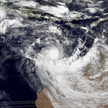
Cyclone Gwenda near landfall on 7 April
Upon attaining peak intensity, Gwenda displayed a well-defined 30 km (19 mi) eye surrounded by deep convection.[2][4] At this time, some monitoring satellites estimated that it had attained winds of 260 km/h (160 mph), equivalent to a Category 5 hurricane.[4] While Gwenda was active, the Bureau of Meteorology stated that its intensity peaked with winds of 215 km/h (135 mph) and a pressure of 915 hPa (mbar).[6] Hours after attaining this intensity, increasing wind shear began to impact the cyclone, causing convection to become elongated and the eye less defined.[2] Rapid weakening commenced as Gwenda turned southeastward towards the Pilbara coastline.[4]
The cyclone continued to deteriorate as it approached Western Australia, with convection displaced ahead of its centre.[2] In addition to the wind shear, Gwenda's forward speed suddenly increased, leading to further disorganisation.[4][5] Late on 7 April, the centre of Gwenda made landfall as a Category 2 cyclone roughly 45 km (28 mi) east of Port Hedland with winds of 100 km/h (60 mph).[2][3] The JTWC estimated the storm to have been slightly stronger at landfall, with winds near 120 km/h (75 mph).[5] Shortly after moving inland, the JTWC issued their final advisory on the weakening storm.[4] The Bureau of Meteorology continued to monitor Gwenda as it abruptly stalled just onshore. However, convection associated with Gwenda continued to stream southeastward due to high wind shear. The storm's remnants persisted for several hours before dissipating early on 8 April.[3]
The Australian Bureau of Meteorology uses 10-minute sustained winds, while the Joint Typhoon Warning Center uses one-minute sustained winds.[7] The Bureau of Meteorology's peak intensity for Gwenda was 225 km/h (140 mph) 10-minute sustained, or 260 km/h (160 mph) one-minute sustained.[3][8] The JTWC's peak intensity for Gwenda was 240 km/h (150 mph) one-minute sustained, or 220 km/h (135 mph) 10-minute sustained.[5][8]
Already suffering from the effects of Cyclone Vance two weeks earlier, which had destroyed or severely damaged 40% of the homes in Exmouth,[10] residents in Western Australia heeded warnings of the impending cyclone. By 6 April, the Bureau of Meteorology had issued storm warnings for areas between Port Hedland and Exmouth.[11]State Emergency Services throughout the threatened areas were put on high alert.[12] Several offshore oil platforms were shut down and evacuated on 6 April and did not reopen until 15 April.[13] Hours before the storm made landfall, the State Emergency Services stated that "Gwenda potentially had the destructive power of Cyclone Vance", and urged residents to seek appropriate shelter.[14][15] Shortly before the storm struck, Len Broadbridge, director of the Western Australia Bureau of Meteorology declared, "Port Hedland is now in grave danger."[16]
Despite the cyclone's strength, its effects were relatively minor. Winds up to 100 km/h (62 mph) were recorded in Port Hedland,[17] leading to minor structural damage.[18] The police in Port Hedland reported severe damage to one house, but no deaths or injuries.[19] Emergency crews were sent to the northwest coast of Australia to assist in cleaning up damages, but found no "major incidents" or significant damage as a result of the storm.[20] A group of five people on a camping trip in the Outback were stranded by the storm, when heavy rains swept away their vehicle. The group "would have perished", but one of its members hiked non-stop for twenty four hours to a manganese mine where he contacted rescuers.[21]
In a 12-hour span, Port Hedland recorded 86 mm (3.4 in) of rain, well-above the average April precipitation total of 23 mm (0.91 in).[22] Towns in the Pilbara region of Australia received heavy rainfall, amounting to 130 mm (5.1 in) in some places.[17] Carlindi picked up the greatest rainfall total of 205 mm (8.1 in).[18] This rain caused localised flooding, especially in Nullagine where the river traversing the town broke its banks.[17] The rainfall contributed to a long-term cooling effect in northern Western Australia, leading to below-average temperatures for much of April.[23]
At its peak Gwenda was the strongest storm on record to form near Australia, surpassing Cyclone Orson in 1989. Gwenda held this record until 2003, when its maximum winds were eclipsed by Cyclone Inigo.[3] Despite the minimal damage, the name was retired from the circulating lists of tropical cyclone names for the Australian Region and was replaced with Gabrielle.[24]
See also
Tropical cyclones portal
Cyclone Mahina – The most intense tropical cyclone recorded in the Southern Hemisphere
Cyclone Monica – Had the strongest maximum wind speeds ever recorded in the Australian basin
^Kerr, Jack (26 December 2014). "Tropical Cyclone Mahina: Bid to have deadly March 1899 weather event upgraded in record books". Australian Broadcasting Corporation. Archived from the original on 2 April 2015. Retrieved 6 March 2015.
^ abcdefghGary Padgett (28 May 1999). "Monthly Tropical Weather Summary for April 1999". Typhoon 2000. Retrieved 2 January 2010.
^ abcdefg"Australian Region Tropical Cyclone Best Tracks". Australian Bureau of Meteorology. 2009. Retrieved 2 January 2010.
^ abcdefgJoint Typhoon Warning Center (26 December 2006). "JTWC Advisories for Cyclone Gwenda". Australia Severe Weather. Retrieved 2 January 2010.
^ abcdeJoint Typhoon Warning Center (2000). "Cyclone 32S (Gwenda) Best Track". United States Navy. Archived from the original on 7 June 2011. Retrieved 2 January 2010.
^Gary Padgett (28 May 1999). "Monthly Tropical Cyclone Tracks for April 1999". Typhoon 2000. Retrieved 2 January 2010.
^"Frequently Asked Questions". Joint Typhoon Warning Center. 2005. Archived from the original on 1 September 2013. Retrieved 2 January 2010.
^ ab"Section 2 Intensity Observation and Forecast Errors". United States Navy. 2009. Archived from the original on 30 August 2012. Retrieved 2 January 2010.
^"Australian Tropical Cyclone Database" (CSV). Australian Bureau of Meteorology. 30 June 2023. Retrieved 30 June 2023. A guide on how to read the database is available here.
^"New Cyclone Threatens Ravaged Australian Towns". Agence France-Presse. 6 April 1999.
^"Tropical cyclone off WA coast upgraded to five". Australian Associated Press. 6 April 1999.
^"WA's north-west prepares for second cyclone". Australian Associated Press. 7 April 1999.
^"Griffin Oil Field Resumes Production After Second Cyclone". Australian Associated Press. 15 April 1999.
^"Cyclone Gwenda nears WA coast". Australian Associated Press. 8 April 1999.
^"Flooding, 200 km/h Winds Predicted as Cyclone Nears". AAP Newsfeed. 7 April 1999.
^"10,000 Prepare for Wrath of Gwenda". The Age. 8 April 1999. p. 2.
^ abc"No damage reported as cyclone warnings cancelled". Australian Associated Press. 8 April 1999.
^ abStaff Writer (May 1999). "Significant Weather - April 1999". Australian Bureau of Meteorology. Retrieved 1 January 2010.
^Reardon, David (9 April 1999). "Cyclone Spares Pilbara". The Sydney Morning Herald. p. 5.
^"Clean-up After Cyclone Fades". The Daily Telegraph. Sydney. 8 April 1999. p. 3.
^Barton, Mairi (10 April 1999). "Family's five-day Outback Ordeal". The Advertiser. Adelaide.
^Lorna Rowley-Gillard (13 April 1999). "WeatherWatch". Guardian Newspapers Limited. p. 15.
^National Climatic Data Center (11 February 2009). "Climate of 1999 - April". National Oceanic and Atmospheric Administration. Retrieved 1 January 2010.
^RA V Tropical Cyclone Committee (2023). Tropical Cyclone Operational Plan for the South-East Indian Ocean and the Southern Pacific Ocean 2023 (PDF) (Report). World Meteorological Organization. Retrieved 23 October 2023.
External links
Joint Typhoon Warning Center (JTWC) Archived 1 March 2010 at the Wayback Machine.
Australian Bureau of Meteorology (TCWC's Perth, Darwin & Brisbane) Archived 12 November 2009 at the Wayback Machine.


 Extratropical cyclone, remnant low, tropical disturbance, or monsoon depression


