Dox Castle
Landform in the Grand Canyon, Arizona


Dox Castle
Location in Arizona
Show map of Arizona
Dox Castle
Dox Castle (the United States)
Show map of the United StatesColorado Plateau
Dox Castle is a 4,780-foot-elevation (1,460-meter) summit located in the Grand Canyon, in Coconino County of northern Arizona, US.[2] It is situated four miles north-northeast of Havasupai Point, two miles northwest of Evans Butte, and 2.5 miles southwest of Holy Grail Temple, where it towers 2,500 feet (760 meters) above the Colorado River.
Dox Castle was named by William Wallace Bass and George Wharton James for Virginia Dox (1851–1941), who was the first white woman to visit this part of the Grand Canyon in 1891.[2][3] Holy Grail Temple was originally named Bass Tomb by Virginia Dox, for William Bass, Dox's guide into the canyon.[4] Impressed by her, Bass named Dox Castle shortly after she left.[5] This butte's name was officially adopted in 1908 by the U.S. Board on Geographic Names.[2] According to the Köppen climate classification system, Dox Castle is located in a cold semi-arid climate zone, with precipitation runoff draining west to the Colorado River via Shinumo Creek.[6]
Dox Castle is composed of Cambrian rock from the Tonto Group, overlaying the Proterozoic Unkar Group at river level. Levi F. Noble named the Dox Formation because of exposures in a tributary to Shinumo Creek below Dox Castle.[7]
Gallery
-
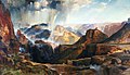 Dox Castle is centered in bullseye of this famous painting by Thomas Moran.
"Chasm of the Colorado" (1873–74), a large canvas measuring 7 feet high by 12 feet wide, hung prominently in the US Capitol for over a half-century. -
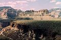
 Holy Grail Temple centered with Dox Castle below to right, from southwest
 -
 Dox Castle centered, King Arthur Castle upper left. From the west.
 -
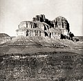
 North aspect, 1901
 -
 Dox Castle circa 1901
 -


See also
References
- ^ a b c d e "Dox Castle – 4,780' AZ". Lists of John. Retrieved December 26, 2020.
- ^ a b c d "Dox Castle". Geographic Names Information System. United States Geological Survey, United States Department of the Interior. Retrieved 2020-12-26.
- ^ Gregory McNamee, Grand Canyon Place Names, 1997, Mountaineers Publisher, ISBN 9780898865332, p. 48.
- ^ Randy Moore and Kara Felicia Witt, The Grand Canyon: An Encyclopedia of Geography, History, and Culture, 2018, ABC-CLIO Publisher, p. 99.
- ^ Lauren A. Wright and Bennie W. Troxel, Levi Noble: Geologist, 2002, USGS, p. 8.
- ^ Peel, M. C.; Finlayson, B. L.; McMahon, T. A. (2007). "Updated world map of the Köppen−Geiger climate classification". Hydrol. Earth Syst. Sci. 11. ISSN 1027-5606.
- ^ Noble, Levi F, The Shinumo Quadrangle, Grand Canyon District, Arizona. (1914), Bulletin no. 549. US Geological Survey, Reston, Virginia. p. 53.
External links
Wikimedia Commons has media related to Dox Castle.


