Gmina Pacyna
Gmina in Masovian Voivodeship, Poland
Gmina Pacyna Pacyna Commune | |
|---|---|
Gmina | |
 | |
 Flag  Coat of arms | |
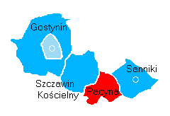 Location within Gostynin County | |
| Coordinates (Pacyna): 52°17′59″N 19°42′45″E / 52.29972°N 19.71250°E / 52.29972; 19.71250 | |
| Country |  Poland Poland |
| Voivodeship | Masovian |
| County | Gostynin |
| Seat | Pacyna |
| Area | |
| • Total | 90.85 km2 (35.08 sq mi) |
| Population (2006) | |
| • Total | 3,947 |
| • Density | 43/km2 (110/sq mi) |
| Website | http://www.pacyna.mazowsze.pl |
Gmina Pacyna is a rural gmina (administrative district) in Gostynin County, Masovian Voivodeship, in east-central Poland. Its seat is the village of Pacyna, which lies approximately 22 kilometres (14 mi) south-east of Gostynin and 89 km (55 mi) west of Warsaw.
The gmina covers an area of 90.85 square kilometres (35.1 sq mi) and in 2006 its total population was 3,947.
Villages
Gmina Pacyna contains the villages and settlements of Anatolin, Janówek, Łuszczanówek, Luszyn, Model, Pacyna, Podatkówek, Podczachy, Przylaski, Radycza, Raków, Rakowiec, Remki, Robertów, Romanów, Rybie, Sejkowice, Skrzeszewy, Słomków and Wola Pacyńska.
Neighbouring gminas
Gmina Pacyna is bordered by the gminas of Gąbin, Kiernozia, Oporów, Sanniki, Szczawin Kościelny and Żychlin.
References
- Polish official population figures 2006
External links
![]() Media related to Gmina Pacyna at Wikimedia Commons
Media related to Gmina Pacyna at Wikimedia Commons
- v
- t
- e
Gmina Pacyna

| ||
|---|---|---|
Seat: Gostynin (urban gmina) | ||
| Rural gminas |
|  |


