McKeldin Square
McKeldin Square is an area of Downtown Baltimore, located near the Inner Harbor at the corners of Pratt and Light Streets.
The central area is a polygon of brick. On the Pratt St. side there is a strip of grass; behind the brick there used to be a pool at the base of a multi-leveled concrete structure with walkways and fountains;[1][2] however, this fountain structure was removed in 2016.[3]
The location of the square puts it right in the middle of Baltimore's 1861 riots, during which locals turned on a Union regiment that was passing through the city.
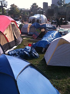
McKeldin Square has been designated as Baltimore's zone for protests, where it is legal to exercise one's First Amendment rights and pass out pamphlets.[4] Permits are required for groups with groups of 25 or more requiring a permit. On October 4, 2011, it became the location of the Occupy Baltimore protests until their December 13 eviction.
References
- ^ Wylson, Anthony (1986). Aquatecture: architecture and water. Architectural Press. p. 63.
- ^ Snedcof, Harold R. (1985). Cultural facilities in mixed-use development. Urban Land Institute. p. 236.
- ^ Gunts, Edward (November 3, 2016). "McKeldin Fountain is the latest Brutalist work to be pulverized in Baltimore". The Architect's Newspaper. The Architect's Newspaper, LLC. Retrieved July 13, 2019.
- ^ Walker, Andrea K. (September 18, 2011). "Spray-paint artist arrested at Inner Harbor". The Baltimore Sun. Retrieved 17 November 2011.
- v
- t
- e
- Annapolis Road
- Art Museum Drive
- Bellona Avenue
- Broadway
- Calvert Street
- Carey Street
- Cathedral Street
- Caton Avenue
- Central Avenue
- Charles Street
- Cooks Lane
- Druid Hill Avenue
- Eutaw Street
- Falls Road
- Fallsway
- Fulton Avenue
- Garrison Boulevard
- Gay Street
- Greene Street
- Greenmount Avenue
- Greene Street
- Greenspring Avenue
- Guilford Avenue
- Greenmount Avenue
- Hanover Street
- Harford Road
- Hawkins Point Road
- Hillen Road
- Hilton Street/Hilton Parkway
- Highland Avenue
- Howard Street
- Key Highway
- Liberty Heights Avenue
- Light Street
- Loch Raven Boulevard
- Madison Street
- Martin Luther King Jr. Boulevard
- Maryland Avenue
- McCulloh Street
- Old Harford Road
- Paca Street
- Park Heights Avenue
- Paca Street
- Park Avenue
- Pennington Avenue
- Pennsylvania Avenue
- Perring Parkway
- Reisterstown Road
- Roland Avenue
- Russell Street
- St. Paul Street
- South Street
- The Alameda
- University Parkway
- Wabash Avenue
- Washington Street
- Washington Boulevard
- York Road
- 25th Street
- 28th Street
- 33rd Street
- 36th Street
- 41st Street
- Aliceanna Street
- Baltimore Street
- Biddle Street
- Boston Street
- Broening Highway
- Centre Street
- Chase Street
- Church Street
- Coldspring Lane–Moravia Road
- Conway Street
- Cross Country Boulevard
- Eager Street
- Eastern Avenue
- Erdman Avenue
- Fayette Street
- Fleet Street
- Forest Park Avenue
- Fort Avenue
- Franklin Street
- Frederick Avenue
- Gwynns Falls Parkway
- Lexington Street
- Lombard Street
- Monument Street
- Mt. Royal Avenue
- Mulberry Street
- North Avenue
- Northern Parkway
- Orleans Street
- Patapsco Avenue
- Pratt Street
- Preston Street
- Saratoga Street
- Sinclair Lane
- Smith Avenue
- Swann Drive
- Waterview Avenue
- Wilkens Avenue
- Battle Monument Square
- Franklin Square
- Johnston Square
- Lafayette Square
- McKeldin Square
- Mount Vernon Place
- National Katyń Memorial Circle
- Park Circle
- Saint Paul Place
- Union Square
- Walbrook Junction
- Washington Monument Circle
- War Memorial Plaza
- Wilkens Avenue Circle
- Baltimore Beltway (I-695)
- Baltimore–Washington Parkway
- Cal Ripken Way (I-395)
- Harbor Tunnel Thruway (I-895)
- Interstate 95
- Jones Falls Expressway (I-83)
39°17′10″N 76°36′47″W / 39.28611°N 76.61306°W / 39.28611; -76.61306
 | This Baltimore location article is a stub. You can help Wikipedia by expanding it. |
- v
- t
- e


