Mullach Glas
Mountain in Galway, Ireland


Mullach Glas
Location in Ireland
Mullach Glas (Irish for "grey/green summit")[2] is one of the Maumturk Mountains of Connemara in County Galway, Ireland. At 622 metres (2,041 ft), it is the fifth-highest of the Maumturks,[3][4] the 197th–highest peak in Ireland on the Arderin list,[5] and 238th–highest on the Vandeleur-Lynam list.[6][3] Mullach Glas is on a massif that includes Binn Mhór (661 metres (2,169 ft)) and Corcogemore (609 metres (1,998 ft));[7] this massif is at the far southeastern sector of the long north-west to south-east spine of the Maumturks.[3]
Name
Irish academic Paul Tempan records that Irish: Mullach Glas translates as "grey/green summit", and that the peak has also been called "Shannagirah".[2]
Geography
Mullach Glas lies on a small massif in the southeast sector of the Maumturks range, which is separated from the main range by a deep east–west mountain pass called Máméan, a site of pilgrimage dedicated to Saint Patrick since the 5th-century.[4][8][9]
To the north east is the minor subsidiary peak of Mullach Glas NE Top (432 metres (1,417 ft)), also known as Cruiscín (probably meaning "jug").[2][7] To the west is Binn Mhór (661 metres (2,169 ft)), the 3rd-highest peak in the Maumturks range, while to the east is Corcogemore (609 metres (1,998 ft)).[3][7][4]
Hill walking
The most straightforward route to the summit Mullach Glas is the 10-kilometre 4–5 hour roundtrip route from the pass at Máméan and back; however, because of its positioning on a high ridge of its own small massif, it can also be climbed as an alternative 10-kilometre 4–5 hour route from Corcogemore in the west, across Mullach Glas, to the summit of Binn Mhór, and then finishing down at Máméan (i.e. the route requires two cars).[7]
Mullach Glas is also climbed as part of the Maamturks Challenge, a 25-kilometre 10–12 hour walk over the full Maumturks range (from Maam Cross to Leenaun), which is considered one of the "great classic ridge-walks of Ireland",[4][10] but of "extreme grade" due to the circa 7,600 feet of total ascent.[7] Since 1975, the University College Galway Mountaineering Club has run the annual "Maamturks Challenge Walk" (MCW),[11] and mans a checkpoint to the west of Mullach Glas in the Máméan pass, and to the east of Mullach Glas on the neighbouring peak of Corcogemore.[12][13]
Gallery
-
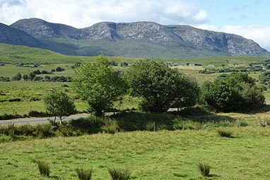 Mullach Glas (left), and Binn Mhór (centre and right), as viewed from the north
 -
 Mullach Glas (back left), and Binn Mhór (centre), viewed from Binn Chaonaigh
 -
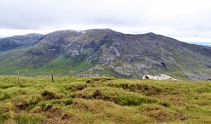
 Summit of Mullach Glas, looking west to peak of Binn Mhór


Bibliography
- MountainViews Online Database (Simon Stewart) (2013). A Guide to Ireland's Mountain Summits: The Vandeleur-Lynams & the Arderins. Collins Books. ISBN 978-1-84889-164-7.
- Paul Phelan (2011). Connemara & Mayo - A Walking Guide: Mountain, Coastal & Island Walks. Collins Press. ISBN 978-1848891029.
- Dillion, Paddy (2001). Connemara: Collins Rambler's guide. Harper Collins. ISBN 978-0002201216.
- Dillion, Paddy (1993). The Mountains of Ireland: A Guide to Walking the Summits. Cicerone. ISBN 978-1852841102.
See also
Wikimedia Commons has media related to Mullach Glas.
Wikimedia Commons has media related to Maumturk Mountains.
- Twelve Bens, major range in Connemara
- Mweelrea, major range in Killary Harbour
- Lists of mountains in Ireland
- Lists of mountains and hills in the British Isles
- List of Hewitt mountains in England, Wales and Ireland
References
- ^ a b c d "Mullach Glas". MountainViews Online Database. Retrieved 9 August 2019.
- ^ a b c Paul Tempan (February 2012). "Irish Hill and Mountain Names" (PDF). MountainViews.ie.
- ^ a b c d Mountainviews, (September 2013), "A Guide to Ireland's Mountain Summits: The Vandeleur-Lynams & the Arderins", Collins Books, Cork, ISBN 978-1-84889-164-7
- ^ a b c d Dillion, Paddy (1993). The Mountains of Ireland: A Guide to Walking the Summits. Cicerone. ISBN 978-1852841102.
"Walk 49: Corcogemore, Mullach Glas, Binn Mhór, Binn Chaonaigh, Binn idir an Dá Log, Letterbreckaun, Leenaun Hill
- ^ Simon Stewart (October 2018). "Arderins: Irish mountains of 500+m with a prominence of 30m". MountainViews Online Database.
- ^ Simon Stewart (October 2018). "Vandeleur-Lynams: Irish mountains of 600+m with a prominence of 15m". MountainViews Online Database.
- ^ a b c d e Paul Phelan (2011). Connemara & Mayo - A Walking Guide: Mountain, Coastal & Island Walks. Collins Press. ISBN 978-1848891029.
Route 16: Corkóg
- ^ Éanna Ó Caolla (5 August 2016). "Pilgrims head to Connemara hills for annual walk". Retrieved 2 August 2019.
The site, which is also associated with the pagan Lughnasa Solstice festivals, features a holy well and a Mass Rock (Carraig an Aifrinn) which was used during the repressive penal times when isolated locations were used to host religious ceremonies.
- ^ "Máméan Pilgrimage". National Museum of Ireland.
High up the slopes of the Maum Turk Mountains in Connemara there is a natural passage-way known as Máméan (pass of the birds). At the summit of this rugged track you will find an ancient pilgrim site dedicated to St. Patrick.
- ^ Fairbairn, Helen (2014). Ireland's Best Walks: A Walking Guide. Collins Press. ISBN 978-1848892118. Retrieved 1 August 2019.
Route 36: The Central Maumturks – South
- ^ "The Maumturks Challenge". University College Galway Mountaineering Club (UCGMC). Retrieved 1 August 2019.
- ^ Simon Stewart. "Maumturks Challenge Section 1: Corcog to Mamean". MountainViews Online Database. Retrieved 2 August 2019.
- ^ "Maaumturks Challenge: The Route". University College Galway Mountaineering Club (UCGMC). Retrieved 2 August 2019.
External links
- The Maamturks Challenge, University College Galway Mountaineering Club
- The Maamturks Challenge: Routecard (2015)
- MountainViews: The Irish Mountain Website, Mullach Glas
- MountainViews: Irish Online Mountain Database
- The Database of British and Irish Hills , the largest database of British Isles mountains ("DoBIH")
- Hill Bagging UK & Ireland, the searchable interface for the DoBIH
- v
- t
- e

Mountains and hills of Connacht | |||||||
|---|---|---|---|---|---|---|---|
| Achill Island |  | ||||||
| Dartry Mountains | |||||||
| Maumturks | |||||||
| Mweelrea Mountains | |||||||
| Nephin Range | |||||||
| Ox Mountains | |||||||
| Partry Mountains | |||||||
| Sheeffry Range | |||||||
| Benna Beola |
| ||||||
| Others | |||||||


