Tallahassee metropolitan area
Tallahassee metropolitan area | ||
|---|---|---|
Metropolitan Statistical Area | ||
| Tallahassee, FL Metropolitan Statistical Area | ||
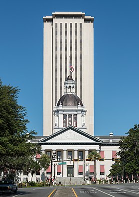
 Florida Capitol buildings (Old Capitol in foreground) | ||
 Interactive Map of Tallahassee–Bainbridge, FL–GA CSA
| ||
| Country | United States | |
| State(s) | Florida Georgia | |
| Principal city | Tallahassee | |
| Other cities | Bainbridge, Ga. | |
| Time zone | UTC-5 (EST) | |
| • Summer (DST) | UTC-4 (EDT) | |
The Tallahassee Metropolitan Statistical area is the metropolitan area centered on Tallahassee, Florida.
The Tallahassee Metropolitan Statistical Area is a metropolitan statistical area (MSA) designated by the Office of Management and Budget and used by the Census Bureau and other agencies for statistical purposes. The Tallahassee Metropolitan Statistical Area consists of the Florida counties of Gadsden, Jefferson, Leon and Wakulla.
- Tallahassee, in Leon County, is designated as the principal city in the MSA.
- Monticello is the county seat of Jefferson County.
- Crawfordville is the county seat of Wakulla County.
- Quincy is the county seat of Gadsden County.
The Florida counties of Leon, Gadsden, Wakulla and Jefferson, plus the Georgia county of Decatur, make up the Tallahassee—Bainbridge, FL-GA Combined Statistical Area (CSA). The Thomasville, Georgia Micropolitan Statistical Area (μSA) also abuts the Tallahassee Metropolitan Area to the north.
History
The Tallahassee Standard Metropolitan Statistical Area was first defined in 1965, and at that time included only Leon County. Wakulla County was added to the MSA in 1973. In 1983, Wakulla County was removed from the MSA and Gadsden County was added. Jefferson County and Wakulla County (for the second time) were added to the MSA in 2003.[1]
Demographics
As of the census[2] of 2000, there were 320,304 people, 125,533 households, and 75,306 families residing within the MSA. The racial makeup of the MSA was 63.59% White, 32.17% African American, and 1.39% from two or more races. 3.72% were Hispanic or Latino of any race.
The median income for a household in the MSA was $34,728, and the median income for a family was $42,957. Males had a median income of $29,628 versus $24,977 for females. The per capita income for the MSA was $17,552.
In 2008 the population of the MSA was 357,259.[3]
See Also
References
- Metropolitan and Micropolitan Statistical Area Definitions - retrieved July 17, 2006
- ^ "Metro Area History 1950–2020". U.S. Census Bureau. March 2020. Row 4179. Retrieved July 27, 2023.
- ^ "U.S. Census website". United States Census Bureau. Retrieved 2008-01-31.
- ^ Tallahassee, FL MSA Population Archived 2006-08-25 at the Wayback Machine - retrieved March 8, 2009
30°18′N 84°12′W / 30.3°N 84.2°W / 30.3; -84.2
- v
- t
- e

50k–100k
10k–40k
 | This Florida state location article is a stub. You can help Wikipedia by expanding it. |
- v
- t
- e


