Yeşilköy Feneri
Lighthouse
40°57′30″N 28°50′21″E / 40.95833°N 28.83917°E / 40.95833; 28.83917
Yeşilköy Feneri is a historical lighthouse still in use located on the northern coast of Sea of Marmara at Yeşilyurt neighborhood (once part of Yeşilköy) in Istanbul's Bakırköy district, Turkey.[6] [7]
History
Built in 1856, it was initially called Ayostefanos Feneri (Hagios Stefanos Lighthouse) after the suburb's former name.[3][5]
The lighthouse was commissioned by the Ottoman sultan Abdülmecid I (reigned 1839–1861) in order to provide safe navigation around the shallow waters before the Yeşilköy Point for ships plying the northwestern coast of the Sea of Marmara towards Istanbul.[5] It is situated roughly 14 km (8.7 mi) to the southwest of the southern entrance to the Bosporus.[3]
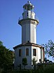
It was built by French engineers in 1856 in the form of a masonry octagonal prism with two stages. Since the ground at the location is not elevated enough from the sea level, the 16 m (52 ft) tower was constructed on a platform, enabling a focal height of 23 m (75 ft).[3] The structure is painted entirely white.[6] A two-story outbuilding is annexed, that was used as the keeper's living quarters and for administrative purposes. A gallery encircles the tower's lantern room. Atop the tower's cupola, a flag post is erected.[4]
Yeşilköy Lighthouse went in service on January 5, 1857.[2] Initially, it was lit by kerosene, but was later replaced by a Dalén light using carbide (acetylene gas). Nowadays, the light runs on electricity. The lighthouse's lantern has a 500mm catadioptric cylindrical lens and a 500 W light source that flashes every 10 seconds in group. Its white light is visible at a range of 15 nmi (28 km). In foggy conditions, a foghorn sounds every 30 seconds to warn of the hazardous area.[3][4][5]
The lighthouse is listed in Turkey under the code "TUR 055" and its radio call sign is TC1YLH.[8] It is maintained by the Coastal Safety Authority (Turkish: Kıyı Emniyeti Genel Müdürlüğü) of the Ministry of Transport and Communication.[3] The lighthouse underwent restoration in the years 1945, 1971 and 1988.[5]
The outbuilding of the lighthouse was converted into a fish and seafood restaurant, which can host 100 guests in the main hall and 40 people in the conservatory. Furthermore, 150 customers can dine on an open-air terrace in the summer months.[9]
See also
 Turkey portal
 Engineering portal


References
- ^ a b Toroslu, M. Vefa. "Denizciye Göz Kırpan Sevdalar-Debiz Fenerleri" (PDF) (in Turkish). DTO İzmir. Retrieved 2010-09-14.
- ^ a b "Deniz Fenerleri-Yeşilköy Feneri" (in Turkish). Balılçı Forum. Archived from the original on 2010-12-27. Retrieved 2010-09-14.
- ^ a b c d e f g h i j k "Historical Lighthouses-Yeşilköy Lighthouse". Ministry of Transport-Directorate General of Coastal Safety. Archived from the original on 2009-09-08. Retrieved 2010-09-15.
- ^ a b c d "Yeşilköy Feneri". Kent Haber (in Turkish). 2009-06-03. Retrieved 2010-09-14.
- ^ a b c d e f g "Yeşilköy" (in Turkish). istanbul.com. Retrieved 2010-09-14.
- ^ a b c Rowlett, Russ. "Lighthouses of Northwestern Turkey". The Lighthouse Directory. University of North Carolina at Chapel Hill. Retrieved 2010-09-15.
- ^ fenerlokantasi.com
- ^ "Marmara Lighthouses On The Air (MLOTA) Award by TCSWAT" (PDF). TCSWAT. Archived from the original (PDF) on 2010-05-25. Retrieved 2010-09-15.
- ^ "Fener Lokantası" (in Turkish). hangirestoran.com. Archived from the original on 2012-03-12. Retrieved 2014-09-29.
External links
- Directorate General of Coastal Safety
- v
- t
- e

| Anatolian coast |
|
|---|---|
| Rumelian coast |
|
| Anatolian coast |
|
|---|---|
| Rumelian coast |
| Anatolian coast |
|
|---|---|
| Rumelian coast |
|
| Anatolian coast |
|
|---|---|
| Rumelian coast |
|
- Polente
- Kaleköy
- Batıburnu
- Tuzburnu
- Babakale
- Sivrice
- Karaburun (Edremit)
- Bozburun
- Güneşadası
- Ilıcaburnu (Aliağa)
- Aslanburnu
- Oğlakadası
- Foça Değirmenburnu
- Güzelbahçe
- Karaburun (Sarpıncık)
- Süngükaya
- Kuşadası Yacht Harbor West BW
- Kuşadası
- Tekağaç
- Turgutreis
- Hüseyinburnu
- Bodrum West BW
- Deveboynu
- Kadırgaburnu
- Keçiadası
| Authority control databases: Geographic |
|
|---|


