Dieterskirchen
| Dieterskirchen comune | |
|---|---|
 | |
 | |
| Localizzazione | |
| Stato |  Germania Germania |
| Land |  Baviera Baviera |
| Distretto |  Alto Palatinato Alto Palatinato |
| Circondario | Schwandorf |
| Territorio | |
| Coordinate | 49°25′N 12°25′E49°25′N, 12°25′E (Dieterskirchen) |
| Altitudine | 499 m s.l.m. |
| Superficie | 24,14 km² |
| Abitanti | 1 060[1] (2006-12-31) |
| Densità | 43,91 ab./km² |
| Altre informazioni | |
| Cod. postale | 92542 |
| Prefisso | 0 96 71 |
| Fuso orario | UTC+1 |
| Codice Destatis | 09 3 76 122 |
| Targa | SAD |
| Cartografia | |
  Dieterskirchen | |
| Sito istituzionale | |
| Modifica dati su Wikidata · Manuale | |
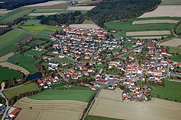
Dieterskirchen è un comune tedesco di 1.060 abitanti, situato nel land della Baviera.
Altri progetti
Altri progetti
- Wikimedia Commons
 Wikimedia Commons contiene immagini o altri file su Dieterskirchen
Collegamenti esterni
- Sito ufficiale, su dieterskirchen.de.


V · D · M Comuni del circondario di Schwandorf  | |
|---|---|
| Città | Burglengenfeld · Maxhütte-Haidhof · Nabburg · Neunburg vorm Wald · Nittenau · Oberviechtach · Pfreimd · Schönsee · Schwandorf · Teublitz |
| Comuni | Altendorf · Bodenwöhr · Bruck in der Oberpfalz · Dieterskirchen · Fensterbach · Gleiritsch · Guteneck · Neukirchen-Balbini · Niedermurach · Schmidgaden · Schwarzach bei Nabburg · Schwarzenfeld · Schwarzhofen · Stadlern · Steinberg am See · Stulln · Teunz · Thanstein · Trausnitz · Wackersdorf · Weiding · Wernberg-Köblitz · Winklarn |
| Controllo di autorità | VIAF (EN) 242176685 · GND (DE) 4230914-1 |
|---|
 Portale Germania: accedi alle voci di Wikipedia che parlano della Germania
- ^ Ente statistico della Baviera - Dati sulla popolazione


